
Main roads were once re-engineered for trams; plenty of space to build bike paths, then

 I’ve been hanging out at Tyne and Wear archives recently, requesting to see plans of Newcastle’s streets from the 1830s through to the 1930s. While the Roads Were Not Built For Cars book is international in scope, it’s instructive to study the evolution of Jesmond Road, close to my home. Today, most people assume this wide, four-lane highway is an extension of the city’s 1970s motorway network and was made to this width for cars but, in fact, Jesmond Road has been this wide since it was laid out in the 1840s. This stretch of Jesmond Road is now often rammed with speeding cars and thundering HGVs, so rammed that it’s not a pleasant road to cycle on. Most who cycle to town in this direction divert on to the curving, narrower, much older Sandyford Road, a less direct route.
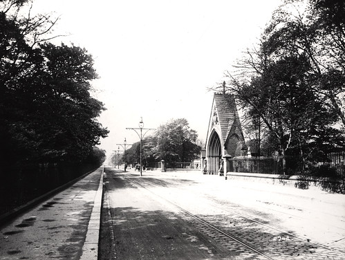
Jesmond Road in its Edwardian heyday. The tramlines are indented with granite setts, lots of cyclists have clearly been using the macadamised strip of road. Macadam is crushed stone. Jesmond Road got its first surface of tar macadam after WW1.
From maps and photos it can be seen that Jesmond Road used to have tram lines on it. The tramlines in Newcastle – like tramlines in many British cities – were extensive and took up a fair bit of roadspace. British tram tracks were 1.4+ metres wide, copying the width popularised by local lad and world-changer George Stephenson. His ‘standard gauge’ of 4 ft 8-and-a-half inches was used on the Liverpool to Manchester railway in 1826 (his North Tyneside wagonway from Killingworth colliery to the staithes at Wallsend, built in 1814, used a 4ft 8in gauge).
Of course, most of Britain’s tramlines were grubbed up in the 1950s to make more room first for omnibuses and then cars. But it’s clear from maps, plans and period photographs, there was once plenty enough road space for trams and cars along the same roads. If that’s the case, there’s easily enough room to accommodate wide bike paths – as well as wider footpaths – alongside the main arterial roads today. (Cyclists are legitimate road users and there should be no campaign to “get cyclists off the road.” Protected bike paths cannot be built alongside every metre of road but would be most useful on those roads avoided by even hardened ‘vehicular cyclists’).

City engineers, transport planners and politicians who say there’s not enough room to install Dutch-style bike paths on British roads don’t know their history. They should go take a look at archive photos, and dig out the highway plans drawn up in the 1880s to the 1930s. The map on the left is from the 1920s and shows the tramlines along the middle of Chillingham Road.
On the tramways map of Newcastle, below, a planner has inked in the type of road surfaces laid beside the city’s tramlines and, when the full 1899 map is in view, the colour coding shows that the tramlines are on the main commuter routes clogged with cars today. These are the most direct routes to and from Newcastle, and without cars, they would be the routes cyclists would also choose to use. It’s these main arterial routes that would most benefit from wide, protected cycle paths.

1899 tramway map of Newcastle
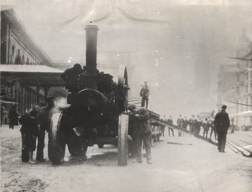
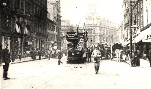
Laying of electric tram lines outside Central Station, Neville Street, 1901
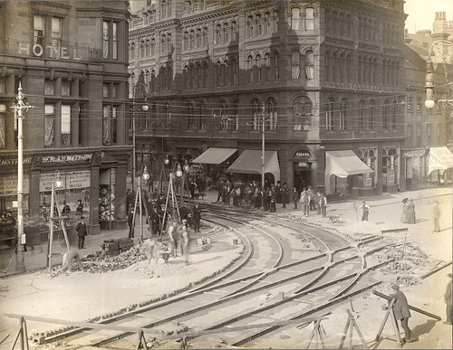
Neville Street, Grainger Street junction, c. 1901
In different eras, Newcastle’s roads have been dominated by pedestrians, waggons, bicycles, trams, omnibuses and, only latterly, cars. Researching the past shows us that things change. The hegemony of the car is taken for granted today, but it isn’t a given. Nothing is set in stone (or tarmac). Delving into the history of Newcastle’s extensive tram network – 51 miles of line at its peak – shows that the great majority of Newcastle’s main roads weren’t originally designed for cars and, with imagination and political will, could be turned into highways fit for the 21st Century. And the urban highways of the future don’t have to be dominated by motorised vehicles. Motor-centrism was one of the defining aspects of the 20th century but finite space, climate change, whole population health, and air quality issues mean that engineers will increasingly have to design for more people-centric towns and cities.
Now, in some cities, re-imagining who and what roads are for could mean the reintroduction of the tram (it’s already happened in Manchester, which was the first city to rip out its tramlines to cater for the car) but it will be far easier and cheaper to design for the bicycle, and for pedestrians. The subjects of King Car have road republicanism in their future.

1933 map of tramlines in Newcastle and Gateshead
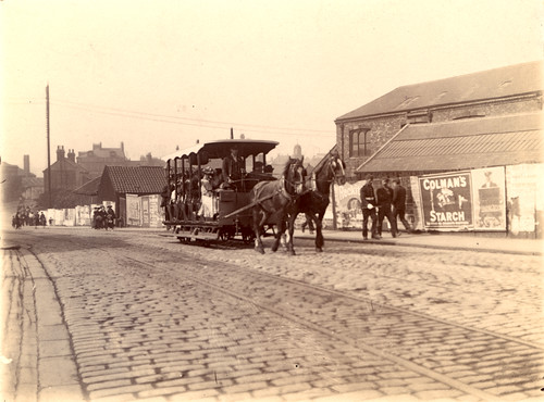
Station Road, South Shields, 1879. The first horse tramways in Newcastle were started in 1879 and operated by The Newcastle and Gosforth Tramways and Carriage Company. By 1893 flush-to-the-road-surface tracks had been laid to Gosforth. The horse tram services stopped operating in April 1901 and electric trams began operating in December of the same year. Most of the main electric tramlines in Newcastle were completed by 1904, with an extension to Fenham coming in 1907 and Shieldfield linked up in 1912. Tramlines tended to be inset with granite setts. These were bumpy for cyclists, who usually preferred to ride on – and lobbied hard for – macadamised (crushed stone) roads. Cyclists always tended to be quicker than trams, even electric ones. Tramlines – then and now – can swallow bicycle wheels.
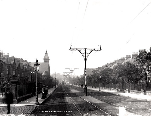
Heaton Road, 1905

Gosforth High Street
City Road
Blackett Street, 1904/5
3 thoughts on “Main roads were once re-engineered for trams; plenty of space to build bike paths, then”